Canada's Ocean Playground
Quebec, Ontario, New Brunswick and Nova Scotia
|
From Toronto via the Niagara Falls, and lakes with beavers in Algonquin Provincial Park to Ottawa, Montréal and Quebec. Watching whales in Tadoussac: Saint Lawrence River and Gaguenay Fjord. Taking a ferry to Gaspesie and via Grand Falls and Saint John to Brier Island in Nova Scotia, Canada's Ocean Playground. And, finally, from Lunenburg to Halifax.
Travelogue: Anje M. Oosterhuis
Photos: Arjan Bolks & Anje M. Oosterhuis
We pick up our rental car, a grey Dodge Impala, at Toronto Lester Pierson Airport. First an extensive inspection, because it has a lot of scratches and dents. And we don't want to be charged for those when we return the car. The mileage is 45,850, let's see how much we can add to that.
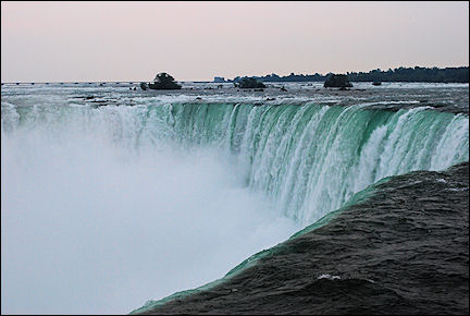
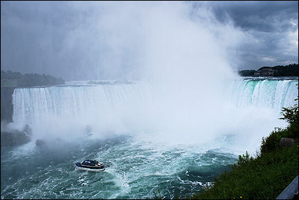
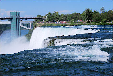
Niagara Falls
The force of the water crashing right next to you is overwhelming
|
From our hotel outside Toronto's city center, we leave for the Niagara Falls the next morning. It's hot but overcast. We park near the waterfalls, and after only a minute's walk we are standing eye to eye with this wonder of nature. And really, the only thing that comes to mind is wow!. It is incredibly impressive.
We walk slowly along the water and take the elevator to get to the "Walk Behind the Falls". We are handed rainwear and walk behind the waterfall to a platform where the water crashes right next to us. And there we get wet!
|
I wonder if all this water comes from the waterfall. My question is soon answered when we see lightning and hear loud thunder. But the feeling of being this close to the waterfall is absolutely wonderful!
We go back up, wander around and then take shelter in the souvenir shop, where the power fails repeatedly because of the heavy thunderstorm. When the weather improves we walk to the American Falls and enjoy the view.
|
The Falls are literally on the border between the US and Canada. We cross a bridge by car and are in the USA. We join a long line of cars that are waiting for their turn at one of twenty custums booths. When it's our turn, a customs officer interviews us. Are we smuggling someone into the country?
We have to wait for 20 minutes in a building until it's our turn to fill out a visa form. All in all it takes over an hour to enter the US.
|
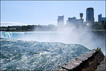
Meanwhile the weather has cleared up completely and the sun shines as if there has been no rain at all. Only the puddles in the street still remind us of the downpour. We cross a pedestrian bridge behind the American Fall and a park to get to the "Horseshoe".
Near the edge of the waterfall the force of the water crashing right next to you is overwhelming. We sit on the grass for a while and enjoy the view. Every now and then we are hit with water when a gust of wind gets underneath the mist and blows it our way.
|
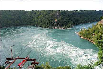
The trip back into Canada is easier, we only have to wait a short moment in line for the customs booths. Via Whirlpool Rapids and Niagara on the Lake we return to Toronto, where it is already dark. Now our jetlag kicks in.
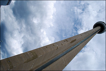
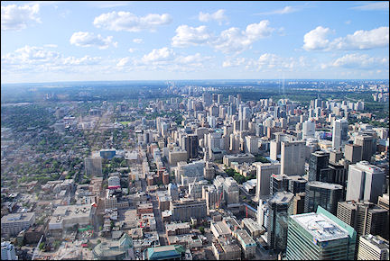
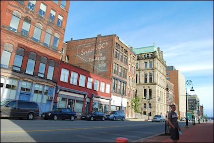
Toronto
A view of the city from an altitude of 351 meters at the CN Tower
|
During our one-day stay in Toronto we visit the zoo in the morning. A 10 kilometers long path winds through the enormous zoo, which also has large accomodations for the animals.
In the afternoon we take the subway to downtown Toronto and visit the Rogers Centre, a large stadium for concerts, baseball, American football, etc., next to the CN Tower.
|
We have made reservations at the restaurant in the CN-Tower at 351 meters. The tower itself is 553 meters high. But when Arjan stands at the foot of the tower, he decides, after long deliberation, that he is afraid to go up. I cancel the reservation but go up by myself to experience the tower anyway.
The elevator is so fast that you're there before you know. This is high!
Huronia and Muskoka
Lakes and Nature Parks
We leave Toronto in northern direction and take Expressway 400 to Barrie and then along Lake Simcoe to Orillia. Lake Simcoe lies in the Huronia region and is close to three provincial parks: McRae, Mara and Bass. Orillia is one of the larger towns in the area.
|
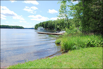
We drive from Orillia to Gravenhurst, the most southern town in the Muskoka region, one of the most popular vacation destinations in Ontario. Muskoka has three lakes: Lake Muskoka, Lake Rousseau and Lake of Bays.
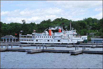
Gravenhurst is the home port of the R.M.S. Segwun, de last real steamer in North America. From May through October you can take a tour of Lake Muskoka with this ship.
We drive from Gravenhurst to Bala by Lake Muskoka. Bala's nickname is Bridge Town, because of the eight bridges in this town. From Bala we drive on to Port Carling. This town is located between Lake Muskoka and Lake Rousseau; originally it was an Ojibwa village, but the white colonists chased away the native population.
|
Around 1885 Mohawks and Caughnawaga arrived in the area and nowadays the "Indian" village on the lake is a place to shop for crafts products.
Just outside Port Carling we find a spot with a picnic bench, which has a fantastic view of Lake Muskoka, so we eat our lunch here.
We drive on to Bracebridge. On the way we pass Huckleberry Rock Cut, two steep walls of granite, carved out by humans.
|
We continue on our drive from Bracebridge to Dorset. We take a wrong turn and end up in the inland, with many hills and potholes; eventually we arrive in Dorset, where will spend the night in Nor'Loch Lodge and Resort on the Lake of Bays.
Algonquin Provincial Park
There are over 10,000 beavers in the park
|
We have to get up early for a hike in Algonquin Provincial Park, because at an early hour you have the best chance of spotting wild animals. We take the 11 kilometers long Mizzy Lake Trail, which takes about six hours to walk, according to the information shield. The trail is marked as "hard".
We start at 8:30 AM. During the first leg, I am a little paranoid: I see angry bears everywhere; later it gets better. At the starting point of the trail we took a brochure which describes 13 spots on the route.
|
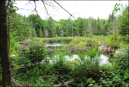
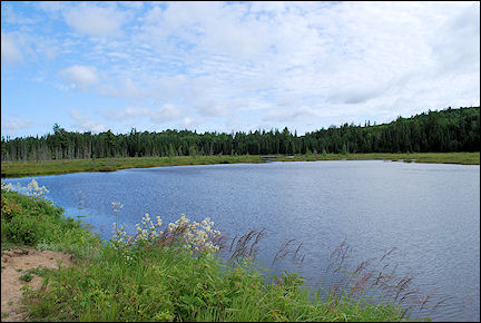
Soon we arrive at two pools where beavers built a dam. Algonquin Provincial Park was founded in 1893 because the beaver population was shrinking drastically. After 15 years beavers already had to be caught and transferred to other parks in North America and to zoos.
Nowadays the beaver population in the park is over 10,000. Other animals that thrive in the same environment as beavers are woodpeckers, swallows, frogs, ducks, turtles, elks and muskusrats.
|
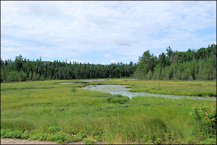
Following the trail we arrive at Mizzy Lake where we should be able to spot otters. We don't see any here, but we do later on our route, at March Hare Lake. Today we also see several turtles. Because of the many ponds with stagnant water, the sun and lack of wind, we are relentlessly bitten by mosquitos.
The trail continues, over tree trunks, roots and rocks and through water ponds. All of a sudden the trail gets easier. We now walk on a path that used to be the trajectory of the Ottawa-Arnprior-Parry railway. It was built between 1894 and 1896. During WWI it was the busiest railway in Canada. Now that the tracks are gone, it has become an important migrating route for wild animals in the park. We see lots of tracks, but unfortunately the animals stay hidden today.
|
Around 1:30 PM we are back at the car, tired but satisfied. The trail took us four and a half hours, not six. We drive back via the West Gate to Dwight, where we buy a vaze at the Indian Trading Post.
Dirty with sweat, mosquito repellent and creepy-crawlies, we take a shower and then rest for a while.
|
After dinner we take the car and return to the park for some wildlife spotting. Unfortunately we don't see elks, but we see a black bear! We see a car slow down and then stop. Often a sign that they have seen something. So we slow down as well and there we see it on the right side of the road.
The bear crosses the road, and we get a warning from the sheriff: we are not allowed to stop on a highway. Well, there were no other cars around, so we don't feel guilty.
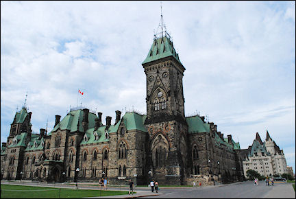
Ottawa
The Rideau canal has eight stepped sluices

|
Our route for today takes us north on Highway 60. We drive through Algonquin Provincial Park and still don't see elks. Too bad, but nature here is so overwhelming that we soon forget about the elks. The road cuts all the way through the park, but the central areas are only accessible by foot or kayak.
When we leave the park, we drive through vast farmlands and via Barry's Bay, Killaoloe and Renfrew to Ottawa, where we will spend the night in the Jail Hostel. It used to be a prison, and interconnected cells now are used as hotel rooms. One floor is kept in its original state.
Compared with Toronto, Ottawa looks like a small provincial town, but it still is the capital of Canada. Bytow, as Ottawa was originally called, was picked as the capital in 1860, to please both Anglophone and Francophone Canadians. Ottawa was named after the Outauac tribe of Native Americans.
After leaving our luggage in our cell in the Jail Hostel, we walk into town. The stalls on Byward Market sell everything imaginable. There are also lots of nice cafés.
|
One of the most important attractions in Ottawa is the Rideau canal, which has eight stepped sluices near Parliament Hill. The canal was openend in 1832 and mainly used for the shipping trade. Nowadays it's mainly used for recreational boating.
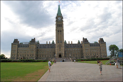
On Parliament Hill are government buildings and the Houses of Parliament and the Peace Tower. The Centennial Flame, which now burns at the southern entrance of Parliament Hill, was lit in 1967 to commemorate the hundredth anniversary of the Canadian parliament.
|
We take a look at the feral cats who live on Parliament Hill and take great pictures of the Ottawa River in the afternoon sun.
Before we leave Ottawa the next day, we walk to Parliament Hill to see the changing of the guards. It's actually wonderful to watch and the musicians who play are very good. It takes exactly 30 minutes and then the band marches off through the streets.
|
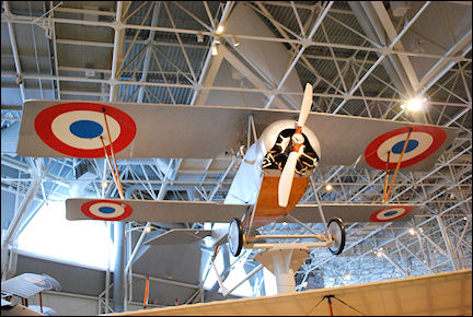
We also visit Canadian Aviation. It has large hangars filled with historic airplanes, also from the first and second world wars. It's a beautifully laid out museum and very interesting. We walk around for two hours before we begin on our drive to Montréal via Highway 17.
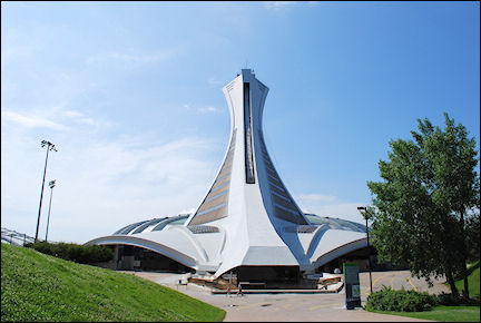
Montréal
The Olympic cycling track now houses four eco-systems
|
The Olympic Games were held in Montréal in 1978. Many buildings are still as they were then. But the Olympic cycling track was converted into the Biodôme in 1992.
The Biodôme houses four eco-systems that are characteristic for North, Central and South America. The pinguins in the Antarctic area are the big stars of the Biodôme.
|
We take the elevator to the top of the tower at the Olympic Stadium. There we have a great view of Montréal. We also walk to the botanical garden, but it is wasted on us.
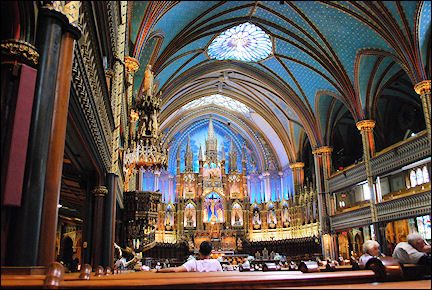
We take the subway to the Basilique de Notre Dame in old Montréal, it is the church in which Celine Dion was married. It is a ridiculously large church with beautiful colors.
Quebec
The old city lies within the city walls
|
We are just in our car, on the way to Quebec, when it starts to rain. We are almost washed off the road and are glad this is only a short drive. It stops raining when we arrive in Quebec.
|
First we make a short visit to Chûtes-de-Montmorency, an 83 meters high waterfall. It is very beautiful, but looks less impressive because of the overcast sky.
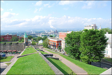
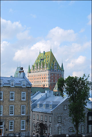
We spend the night in Auberge International de Quebec, in the old city within the city walls. It is dry now and we take a walk on the old city wall to a military base. From there we walk down to the Vieux Port where Chateau Frontenac is located.
This week, there is a festival in Quebec, and tonight Sting performs. It is busy and lively in the city - street theater performances everywhere. It is a little hard to find a table in a restaurant. Back at the hotel we enjoy Sting from our bed.
Tadoussac
Many whales forage in a salty river, rich in food
|
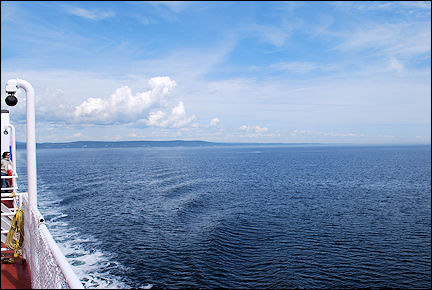
We continue on our trip to Tadoussac. The weather report is good today. We leave Quebec in north-eastern direction and drive along the Saint Lawrence River. For long periods of time we can see the river, only every now and then the road leads away from it. We drive through a landscape of rolling hills with beautiful panoramic views.
We stop every now and then to enjoy the insanely beautiful scenery. This area on the north bank of the Saint Lawrence River is called Charlevois Coast; it officially begins in Beaupré and ends at Tadoussac on the tributary Saguenay River.
|
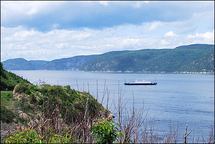
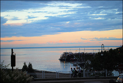
In Baie-Ste-Catherine we drive the car onto the ferry for a short crossing of the Saguenay River, which looks like a fjord in this spot. On the other side we arrive in the village of Tadoussac.
Tadoussac is the oldest trading post in Canada (it dates from 1600), and lies where the Saguenay River drains into the Saint Lawrence. The village has a few restaurants and stores, which carry many local products.
|
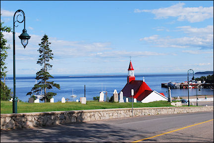
Tadoussac has a really fantastically beautiful white church with a bright-red roof which stands out wonderfully against the surroundings. It is Canada's oldest wooden church; it was also built around 1600.
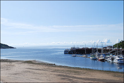
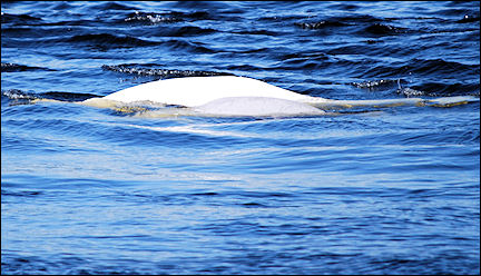
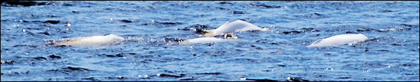
We take a walk on the promenade, along the church, to the port. There is a small beach and many boats are docked in the port. The Saint Lawrence and Saguenay rivers are deep at this point. Because the salt ocean water flows far into the Saint Lawrence River, many whales, among them beluga (white) whales, come to forage here from July to October.
|
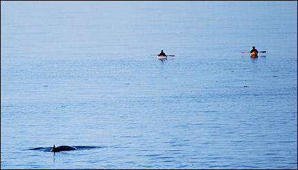
The next morning we take a boat tour of the rivers to see whales. We arrive early, so we still have time to walk past the port to an observation point where the Saint Lawrence and Saguenay rivers merge. From here we already see a few whales.
A little later we board the boat. Just off the coast we already see the first whales. From relatively close up, we see beluga whales, harbor porpoises, minke whales and some seals.
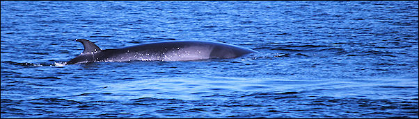
First we sail up the Saint Lawrence and later up the Saguenay. The Saint Lawrence is a tidal river. With high tide it pushes salt water into its tributary Saguenay and with outgoing tide it receives freshwater from the Saguenay. This creates an eco-system in which plankton thrives, which attracts shellfish like krill and shrimp and also small fish: food for the whales.
Back on land we drive to Sacré-Coeur. We pay an entrance fee and enter Provincial Park Saguenay, where we park the car at a small visitors center and walk to an observation point over the Saguenay.
|
After a hefty walk we are rewarded with incredible views of the Saguenay and belugas, white whales, which are on the verge of extinction. By the time we return to our car, it's already dusk.
Gaspé
Along the lovely south bank of the Saint Lawrence
|
About 10 kilometers from the ferry dock in Les Escoumins is a whale observation point in the Saint Lawrence River. After a short walk we see some small whales at a distance of 150 meters, and later a big one only a few meters off the coast.
Near the ferry we see a large shoal of beluga swim up the Saint Lawrence. Crossing from Les Escoumins to Trois Pistoles on the south bank takes one and a half hours. From Trois Pistoles we travel east to Gaspé, on the estuary of the Saint Lawrence River at Saint Lawrence Bay.
|
The peninsula of Gaspé (Gaspésie) is a spit of land which extends east of Quebec along the south bank of the Saint Lawrence River. The north bank is rocky, here it is more charming. But the inland is wild, thanks to the Chic-Choc Mountains, northern foothills of the Appalachian Mountains.
Gaspésie is a popular vacation destination for Canadians. Jacques Cartier first set foot in North America in 1534 in Gaspé. The old wooden memorial has been replaced now with a stone Croix de Gaspé.
|
The distance we cover today is actually too long for one day: over 500 kilometers on a beautiful scenic route, which means that our speed averages 60-65 k/p/h, so we arrive at our motel in Gaspé, motel Fort Prével, only at 8:30 PM.
Grand Falls
Along fishing villages and a pierced rock in the sea
|
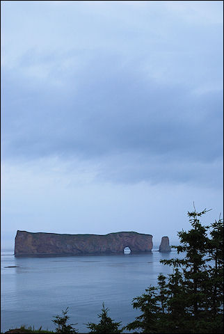
Today we start on our long trip to Grand Falls. One of the first villages we pass, is the fishing village Percé. Its most famous sight is Rocher Percé (Pierced Rock), a gigantic rock just off the coast. When it's low tide you can walk to it.
It really is a very pretty route with all those fishing villages. But still, if we would have known everything in advance, we would have skipped the drive to Gaspé and would have driven directly from Tadoussac to Grand Falls.
If the route would have been half this long, especially in this rainy weather, it would have been much more fun. Another option is to take two days to drive it, but unfortunately our planning does not allow for that.
It really rains all day and leaving the car is not an appealing thought.
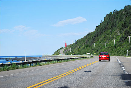
We leave the coastline south of Gaspésie and drive into the inland from New Brunswick to Grand Falls.
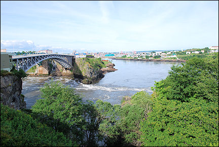
Saint John
100 million tons of water swirls in and out of the Bay of Fundy
|
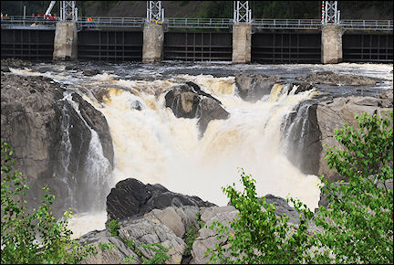
We drive from the village with the same name to the Grand Falls. Here the Saint John River crashes 23 meters down; it is one of the largest waterfalls east of the Niagara Falls.
|
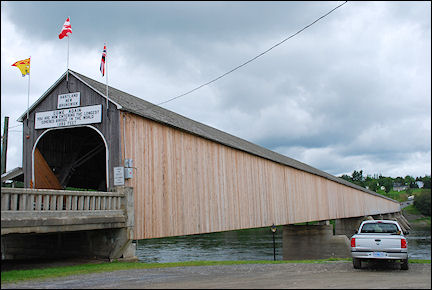
On the way to Saint John we pass the longest covered bridge (391 meters) in the world, in the town of Hartland. We have to drive into the village itself to see it, but it's worth a visit. We cross it by car and then return to Highway 2.
Saint John, an old city (founded in 1785) on the estuary of the river of the same name, is the largest town in New Brunswick. It is an important harbor and has the largest oil refinery of Canada. Its historic center has been restored and the Old City Market is still in business.
|
Saint John is nicknamed Fog City because of the dense fog which often comes in from the Bay of Fundy, into which the Saint John River drains. The Bay of Fundy, between New Brunswick and Nova Scotia, has the most extreme tidal movements in the world: the tide rises and falls up to 16 meters.
Everywhere else in the world the maximum difference between high and low tides is 10 meters. Twice a day over a 100 million metric tons of water swirl into and out of the Bay of Fundy; this water flow is equal to the daily drainage of all rivers in the world combined.
|
The tide causes an unusual natural phenomenon in the Saint John River: Reversing Falls Rapids. During low tide the Saint John River flows through a narrow canyon with rapids and whirlpools into the Bay of Fundy. During high tide, the water swirls upstream through the canyon, raising the water level with 4.5 meters.
In the evening we have dinner in a restaurant with outside seating and a great view of the Reversing Falls.
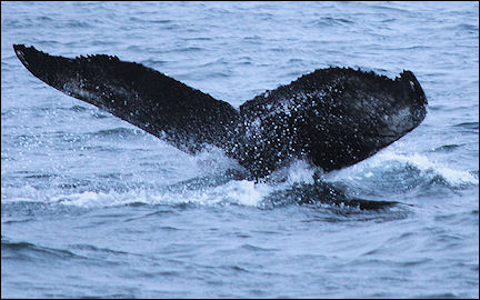
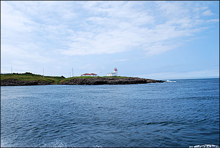
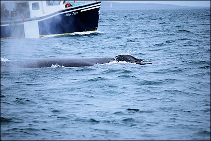
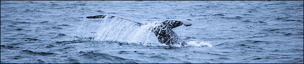
Brier Island
The humpback whales show off their tricks
|
It's raining when the ferry leaves at 12:30 PM and the sea is a little rough. We arrive in Digby, Nova Scotia, after three hours. We are on the other side of the Bay of Fundy now. We drive toward Brier Island. The road goes straight through a narrow peninsula.
We pass Lake Midway and Sandy Cove. At East Ferry we have to take another ferry, for a short crossing. After a short drive we have to get on a ferry again, in Freeport. It will take us to Westport on Brier Island. The ferries lie slanted in the water because of the strong current.
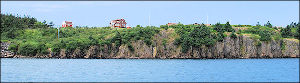
Around 6 PM we arrive on Brier Island. It is raining again. There are a supermarket, a gas station, a lodge and a hostel on this small island. And that's it.
We booked an excursion to spot whales with Brier Island Whale and Seabird Cruises. It is an organization that researches whales. To finance their research, they offer excursions for tourists.
|
It's very foggy and we don't get to see any whales, just one seal. We are given a ticket for a free extra excursion. We use it the same afternoon, when the weather is much better.
All in all, we see three humpback whales and these "clowns of the sea" are in excellent shape. They "perform" all kinds of tricks, like jumping and slapping the water surface with their tails.
After our boat ride we take our leave of Brier Island and drive back on the same road to Digby.
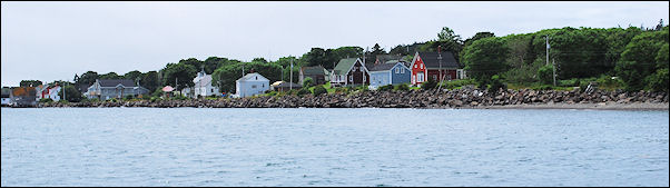
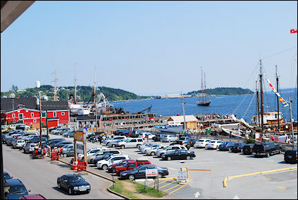
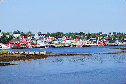
Lunenburg
Brightly colored wooden colonial buildings
|
From Digby we take the road along Kejimkujik National Park. This park is very suited for outdoor activities like hiking and kayaking. We sit on a beach for a while and relax, and then drive on to Lunenburg, a town on the south coast of Nova Scotia.
Lunenburg is on the Unesco World Heritage List, with the remark that it is an excellent example of a British colonial settlement in North America. The town is built in a grid pattern and the brightly colored wooden colonial buildings are well preserved.
|
Lunenburg has the largest fish processing plants in the world. In the past the main catch was cod, but nowadays it's mainly scallops. Our hotel is in the town center, on the waterfront where many large sailing boats are docked.
There's a lot of tourism here. Tourists are driven through town in coaches, while getting information about the history of the town.
|
The receptionist tells us that there is an observation point with incredibly beautiful views of the town. She hasn't said a word too much. We sit on a bench and enjoy the view, remembering our vacation, which is almost over: tomorrow we fly home.
We drive from Lunenburg to Halifax. There we return the car. According to the mileage we have driven over 4,000 kilometers.