Touring Iceland I
South coast: from Seydisfjordur to Reykjavik
|
Driving along the south coast of Iceland you are treated to all kinds of wild landscapes: bizarrely shaped fjords, snow-covered mountain peaks, glaciers, lakes with lumps of ice in them, canyons with fast flowing rivers, steep cliffs and rocks with nesting sea birds, pseudo-craters, moss-green lava fields, basalt rocks enveloped in ancient legends, geysers, bubbling mud pots and steam holes. And waterfalls, many, many splashing waterfalls.
Travelogue & photos: Willem & Christiane Mosselmans-De Coster
We left the port of Tórshavn on Faerøer yesterday late in the afternoon and around 7 AM we see land again.
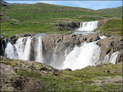
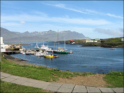
An hour later we see a city appear: Seydisfjordur. Another hour and we arrive on Iceland and drive our car off the ferry. We immediately notice the high waterfall opposite the port.
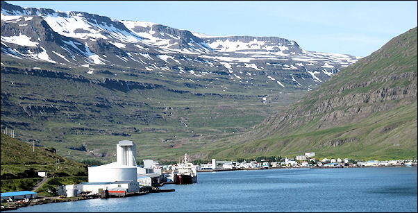
Seydisfjordur is a small town in the eastern part of Iceland, located on a 16 kilometers long snaking fjord of the same name and surrounded by steep mountains with little patches of snow here and there. Every week the ferry Norrona - coming from Hanstholm in Denmark, via Torshavn, Faerøer - docks here.
East coast
Waterfalls, glaciers, high mountains and deep fjords
|
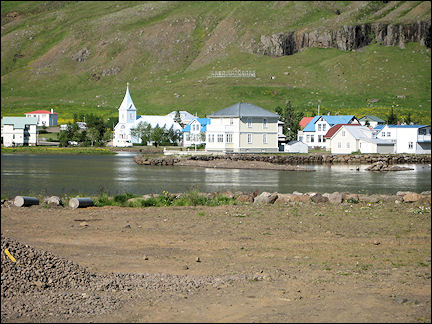
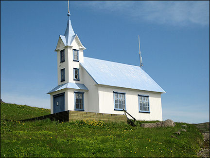
We drive around for a bit in Seydisfjordur and visit a pretty, light-blue painted church with white windows. The town has many colorful wooden houses. A little later we see several waterfalls.
|
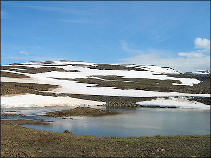
We continue on to Egilsstadir, Iceland's main port of entrance. The road from Seydisfjordur to Egilsstadir takes us over the Fjarðarheiði Pass, which is still covered with snow.
|
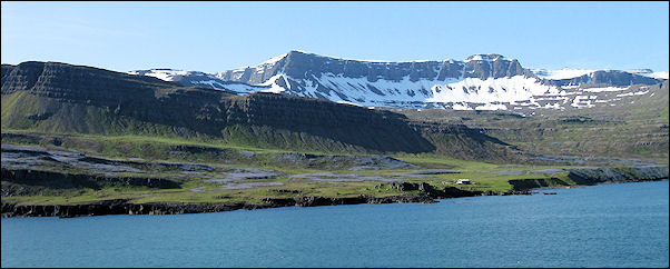
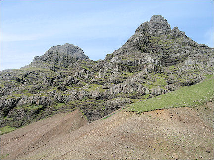
Because our route takes us clockwise around Iceland, we skip Egilsstadir and turn south, taking roads #92 and #96 to road #1. The beautiful east coast has high mountains and deep fjords.
In Redarfjordur (another deep fjord surrounded by high mountains) and Faskrudsfjordur we stop to take in the beautiful landscape. We can't get enough of it.
|
In Stodvarfjordur, again a town on a fjord with the same name, we see an old church converted into a hotel. Here we see lupins for the first time on Iceland. We will see them all over the place, they grow in the wild everywhere.
|
Our next stop is Breiddalsvik, a small fishers village on a fjord with the same name. We visit Petra Sveinsdottir's unique stone collection. Petra has another stone museum on the other side of the fjord. We must have passed it without noticing.
|
We continue on our route in southern direction, to Djupivogur on the Berufjordur, another pretty fishers village on a fjord. After leaving Djupivogur we almost immediately are on a part of the ring (road #1) which hasn't been asphalted yet. But we can see that they're working on it.
|
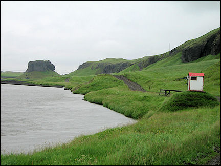
We take a walk in Hofn, which has a glacier museum where you'll find information about the Vatnajokull glacier and the underlying Grímsvötn volcano, which erupted in 2004. A little farther, we stop at a black sand beach.
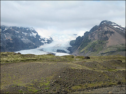
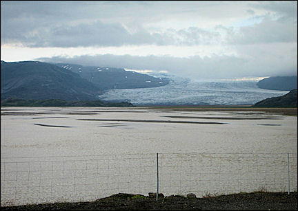
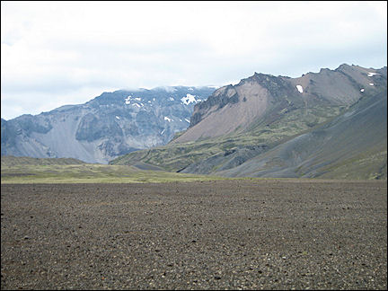
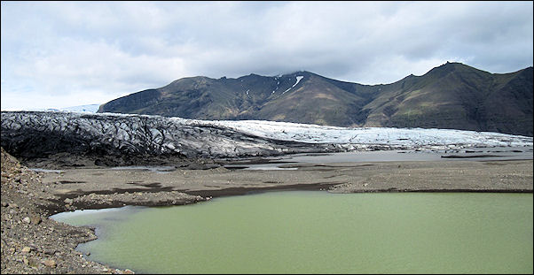
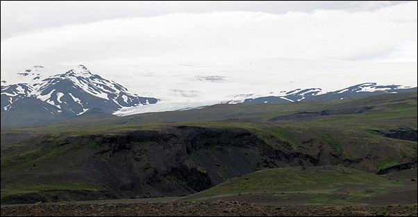
For a while now, we have seen the Vatnajokull, which dominates the landscape with its large glacier tongues. Because we don't have a good picture of the condition of the roads on Iceland, we decide to drive directly to Brunnholl, where we will spend our first night in the Brunnholl Farm.
Behind our room are some horses and cows, but otherwise we don't see any farm activity. Near the farm is a remarkably beautiful church, with a red frieze and a red roof. Our accomodation is wonderfully located just in front of the Flaajokull, a beautiful glacier tongue on the Vatnajokull.
South-east coast
Broken-off ice blocks float to the sea
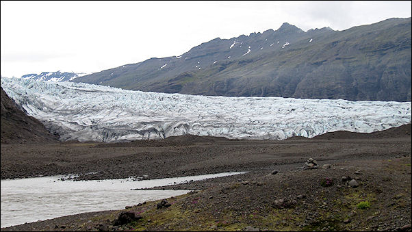
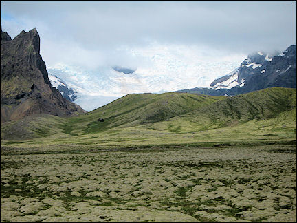
After breakfast we leave for the Flaajokull glacier opposite our accomodation. We drive a short while on road #1 and then on a gravel road in bad condition, until we arrive at the foot of the Flaajokull. It's majestic.
The weather is dry, still a little cool, but considering the early hour it's probably going to be a beautiful day. We return to the #1 and stop again at a panoramic view point, where we enjoy the view of the glaciers.
|
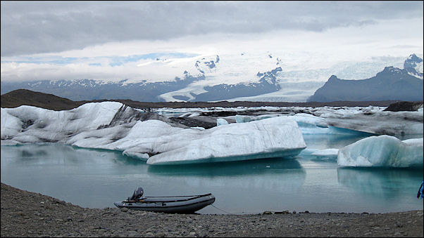
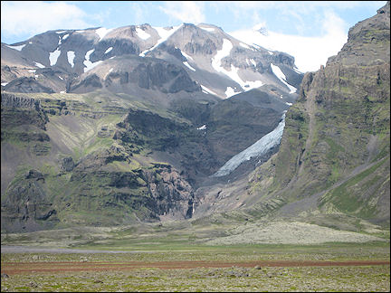
We continue on through a deserted landscape to Jokulsarlon, a glacier lake in which icebergs float and which lies in the shadow of the 2,110 meters high Hvannadalsnukur, the highest mountain peak on Iceland. It lies on the edge of the Oraefajokull strato-volcano. These giant mountains are all part of the Vatnajokull range.
|
You can take a boat tour between broken-off lumps of ice. We find ourselves in a fairy tale. The smaller lumps of ice float to the sea via a small opening. On the other side of road #1 you can see ice cubes float in the ocean if you're lucky.
|
We continue on to Skaftafell. The landscape is still dominated by the Vatnajokull mountains and glacier tongues. Now we understand why all Iceland guide books tell you to bring lots of disk space or film rolls: you will take more pictures than you expected.
Near Hofsnes we drive to the starting point for excursions to Ingolfshofdi. Too bad, we're a quarter of an hour late and nobody is there. We continue on to Skaftafell Nationaal Park. We find information, a good cup of coffee and some food in the information center.
|
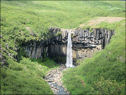
After that, we begin our 1.5 kilometers climb to Svartifoss. It is exhausting, but we are rewarded with a fantastic view. Svartifoss, also known as the black waterfall, hurtles down into the deep over symmetric basalt columns that look like organ pipes.
We return and take a road, to the right of the information center, to Skaftafellsjokull. The last leg is difficult, but the extraordinary view is once again ample compensation.
|
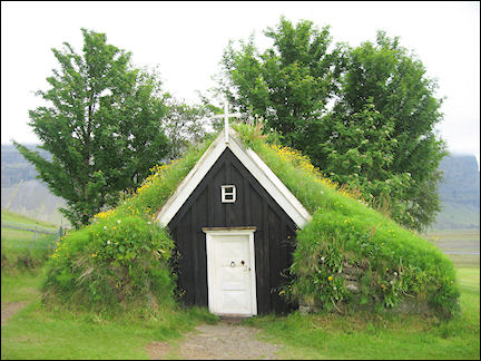
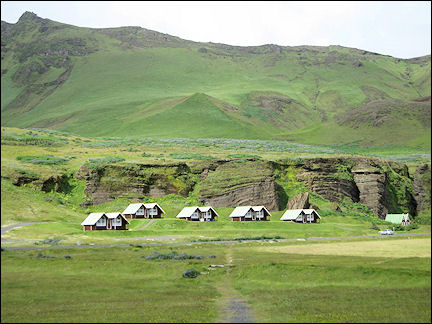
We make a short stop in Nupsstadur, which has one of the oldest peet churches in Iceland. The church seats eight people and a minister. It belongs to an old farm at the foot of the rocks. Here we have a great view of a protruding, 688 meters high cliff, Lomagnupur.
Four kilometers farther is the Islandia Hotel in Nupar, where we will stay for two nights.
Kirkjubaejarklaustur region
Fjadrárgljúfur is one of the most beautiful canyons of Iceland
|
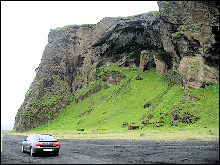
After breakfast we leave for Kirkjubaejarklaustur. It is 12 degrees centigrade, but there's a strong wind and it feels cold. On the way we stop at the "dwarf" cliffs Dverghamrar and the nearby Foss-à-Sidu, a waterfull near a farm.
Just before we reach Kirkjubaejarklaustur we take the exit to Kirkjugolf where we see another pretty waterfall, Stjornarfoss by the camping ground Kleifar.
|
We turn and drive to Kirkjubaejarklaustur. Supposedly some Irish monks lived here before Iceland was colonized. The town got its name from the Benedictine convent which stood there from 1190 until the Reformation in 1550. We also visit the church, a modern building.
|
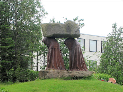
On the square in front of the church is a memorial: two nuns who carry a heavy rock on their heads. According to legend, this refers to the rock where two nuns, who were suspected of heresy, were burned alive and buried. We take a road in southern direction and a little later we see the rock, it's called Systrastapi (Sisters Rock).
|
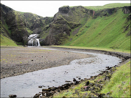
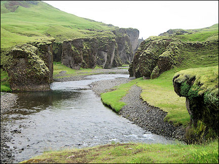
We return and following the road to Laki (F206) we arrive after a few kilometers at one of the most beautiful canyons in Iceland, Fjadrárgljúfur.
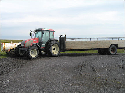
Via Kirkjubaejarklaustur we drive back on the hringvegur (Ring, road #1) to Hofsnes, where we take a guided excursion by tractor with trailer to Ingolfshofdi.
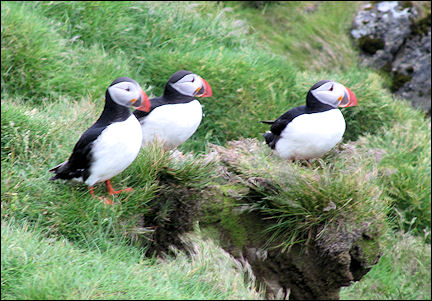
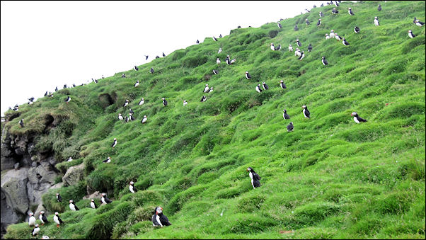
Excursion Ingolfshofdi
Visiting Atlantic puffins by tractor with trailer
|
Ingolfshofdi is a small, 76 meters high rock island with thousands of nesting sea birds, among which the Atlantic puffin. There is a strong wind and it's cold. After a twenty minutes drive through an inlet and a river we arrive at a mound of volcanic sand.
|
Climbing is tough: the rock is high and very steep, there is a head wind and we keep sliding back in the soft sand. This is the beginning of our walk and also the hardest part. When we have reached the top our walk goes smoothly on the hilly terrain.
We start at the memorial stone for Ingolfur Arnarson, who discovered Iceland in 874 and who is believed to have spent that winter here. Ingolfshofdi was named after him. There also is a lighthouse and some kind of shelter. The view of the surroundings is wonderful.
|
Our guide, armed with binoculars, gives us lots of good information in English, he could well be an orithologist. After we have spied on the large birds of prey for a while, we see Atlantic puffins, hundreds of them, sitting on the rocks. We can admire them from close up, it is as if they are posing for the tourists.
According to our guide we are lucky that it's very windy, because in this weather the birds stay on the rocks. We continue on our walk around the bird rock and we are frequently attacked by large birds of prey. We stick up our arms or umbrellas, keep walking and try to stay in the group as much as possible.
Suddenly we see two birds of prey who have caught a puffin and are now busy devouring it. Here and there we see eggs. After a 3 kilometers tour, we begin on our descent.
Vik on the south coast
Pitch-black beaches, caves and basalt
|
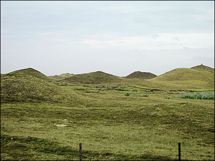
We leave for Vik, at the foot of the Reynisfjall. Past Kirkjubaejarklaustur we take road #204 to Seglbudir. Here we drive between pseudo-craters. We turn and take the same way back and then follow road #1 again in southern direction, which takes us past Landsbrotholar, the largest group of pseudo-craters on Iceland.
Then we pass the lava fields of Eldhraun, which are overgrown with moss. The lava was produced by an eruption of the Lakagigar volcano in 1783 which lasted for nine months and was the most catastrophic one ever to take place on Iceland.
|
We are driving on the sand plain of Myrdalssandur. Just before we reach Vik, we turn onto the road to the cape of Hjorleifshofdi, named after Hjorleifur, a friend of Ingolfur Arnarson who landed here long ago. Here the road disappears.
Orienting ourselves by the rocks to find the road when we turn back, we suddenly see a traffic sign: only for 4WD cars.
|
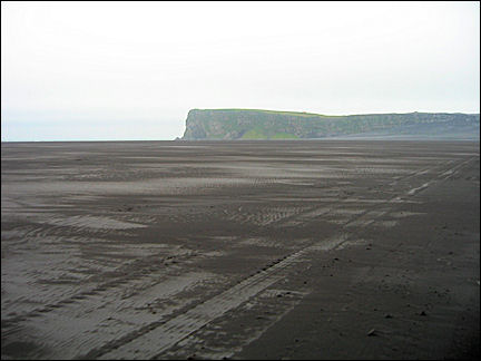
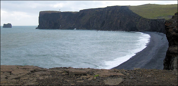
Too bad. We turn and go back to road #1 and drive to Vik. We explore the place, the most southern town on the mainland and also the spot that gets the most rain. It looks like a larger town: opposite the hotel is a shop, a gas station and a restaurant. From here we can see the rock formations of Reynisdrangar.
We take road #218 to Dyrholaey, a 120 meters high rock with a big hole in it that rises from the sea. Except for a few drops of rain, it's been dry all day. But unfortunately there is a strong wind. We are litterally blown away on the rock in Dyrholeay. We climb down to the pitch-black beach, which is spectacular.
We take road #1 in the opposite direction for a while and then turn onto road #215 to Reynisdrangar, almost directly on the other side of Dyrholaey, where we take a look at the basalt rocks. The 66 meters high rock needles in the sea are - according to legend - three trolls who wanted to sink a three-master, but who turned into stone at the break of day instead.
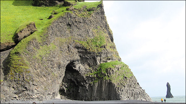
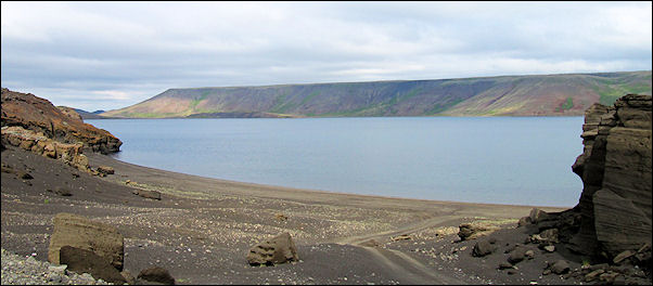
We also visit a cave on the south slope of the 340 meters high Reynisfjall and make a short stop at the Reyniskirkja, a church dating from 1897. Then we take road #2208. The condition of the road is better than expected, we have got used to worse. Soon we arrive at Heidar Vatn, a lake in a deep valley surrounded by high mountains.
|
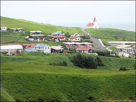
Back in Vik we drive to the high-lying church with a nice view of the surroundings. The church is painted white and has a red roof which makes it stand out in the landscape.
Fludir east of Reykjavik
Glacier tongues and series of waterfalls
After breakfast we leave for Skogar. It's 9 degrees centigrade and there still is a strong wind that makes us feel cold. We take the #1 again and on the way we have great views of the Myrdalsjokull, an ice cap that covers the Katla volcano.
We drive on road #221 - in bad condition - through a wonderful valley to the Solheimajokull, a glacier tongue on the Myrdalsjokull.
|
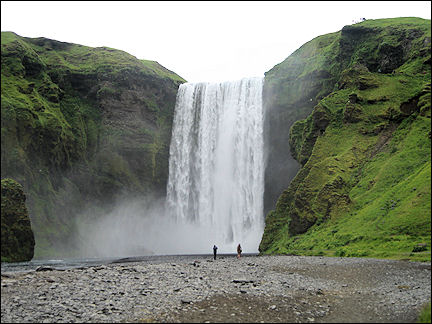
Once we have returned to the #1, we drive to Skogar. We visit the wide Skogafoss waterfall in the Skoga river, the last of a series of smaller waterfalls, which crashes down 62 meters with thundering noise. To the right of the waterfall is a narrow, steep path up, where you have a great view. This is also the starting point of a trail to Thorsmork, a ten-hours mountain hike.
The Skogar Folk Art Museum is housed in an old peet farm. There are several buildings on the property, among which a school, a church and some little houses with beautiful interiors. In the main building is a very interesting folk art museum.
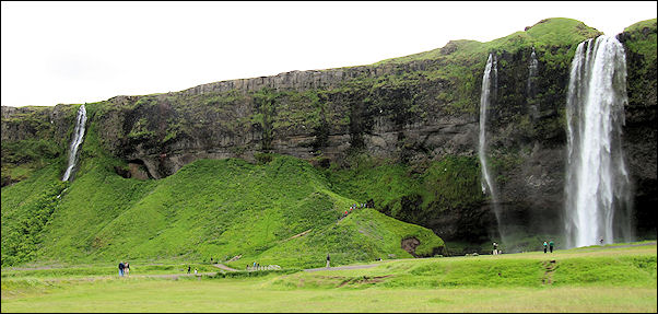
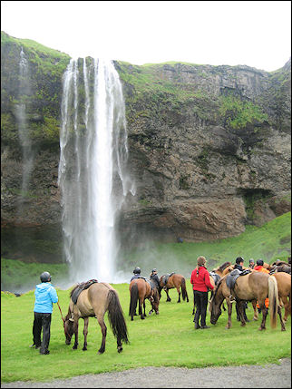
We take road #249 and soon arrive at the Seljalandsfoss, another very pretty, 40 meters high waterfall near the exit to Thorsmork. It's possible to walk behind the waterfall, but you'll get drenched and it's no walk in the park: you have to climb and clamber.
|
We leave for Hella. Near Hvolsvollur we see Hekla on our right, the most famous and most active volcano on Iceland. We try to drive our 2WD to Landamannalaugar via road #26, which is in bad condition, but leads along the Hekla. The volcano is 1,450 meters high and is still covered in lots of snow.
There also is a shorter route to Landmannalaugar, F225, but that one is out of the question for us: it's only for 4WDs, because you have to cross a river.
We drive to Hrauneyar and decide - despite negative advice - to continue on the #26 to the #208 which wil take us to Landmannalaugar, just to find out what this road is like...
It's bad, but we are trying anyway. Meanwhile, it's already 4 PM and we have to reach Fludir today. About 30 kilometers from our destination we decide to turn.
Golden Circle
Spectacular waterfalls and erupting geysers
The Golden Circle is a must for visitors in Iceland, with the geysers Strokkur and Geysir, the Gullfoss waterfalls and National Park Thingvellir on the fault line between the European and American continents.
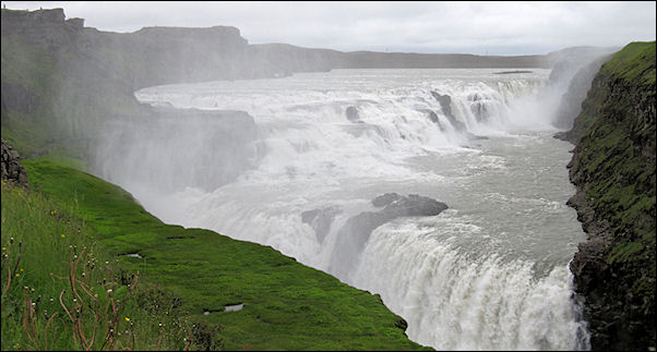
We take road #30 north to Gullfoss. There is a thick fog in the mountains. We make a short stop in Foss to admire a nice waterfall: it's not so high, but very wide. Via road #36 we drive to Gullfoss, a very impressive waterfall in the Hvita river. It crashes down 32 meters in two stages. Incredibly spectacular.
|
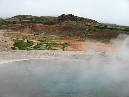
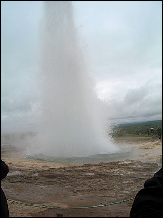
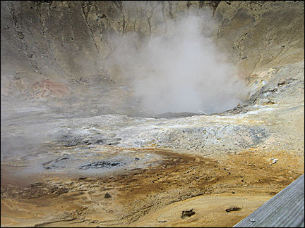
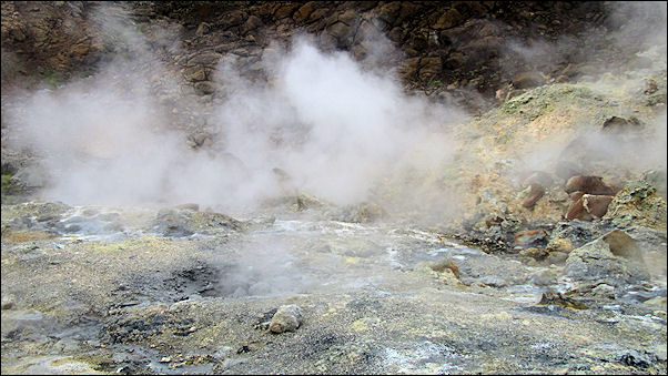
We continue on to the geothermic area Geysir. You can't miss it: from afar you see smoke plumes rise and then there's the smell. We first take a look at Geysir, even though Strokkur draws more attention. Every 5 or 6 minutes it spouts boiling water up to 15-20 meters in the air.
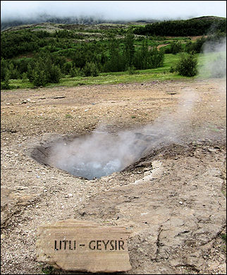
We explore the area and admire Little Geysir also. It bubbles cheerily and erupts little trickles. Geysir itself is quietly steaming, it doesn't do anything else. There's a strong smell of sulphur (rotting eggs).
|
We drive on to the third place on the Golden Circle, Thingvellir. We stop in Laugarvatn to take a walk. But unfortunately the air is black with small mosquitoes which are a real nuisance. So we keep driving. After crossing the mountain pass Lyngsdalsheidi we arrive in Thingvellir.
On this plain Europe's first parliament was established in 930; it was called Althing. It would last for almost 900 years. Until 1798 representatives of the people and important and less important citizens would gather here every summer to party, hold trials, make new laws, exchange news and take care of important business.
|
We visit Lögberg, Rock of the Laws, where an announcer declared the laws to the people. In the Logretta laws were discussed before they were announced, both spots are in the eastern part of the Almannagja canyon.
In the "lake of drowning" Drekkingarhylur in the Oxara river sentenced women were drowned. On the spot where in 1016 one of the first churches on Iceland was built after the population converted to Christianity, now stands a pretty wooden church, painted white with green shutters and a black roof. It's called Thingvallakirkja and dates from 1859.
We walk up the stairs to the Oxararfoss waterfall which drops 20 meters from the Aklmannagja gorge in the Oxara river.
Reykjavik
The straight streets are remarkable
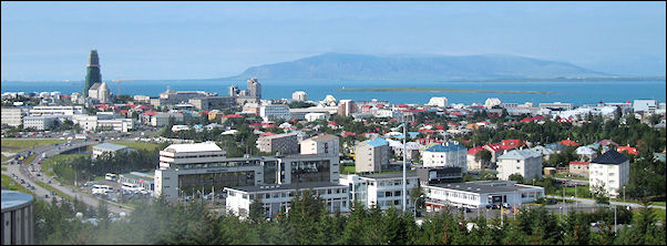
We continue on our way to Reykjavik, the most northern capital in the world, located at the foot of the 914 meters high Esja mountain. It's unusually busy here - for Iceland - and the highway (the road here deserves that name) is great and even has three lanes in some places.
After we have checked in, we leave our hotel on foot for the Hallgrimskirkja, the largest church in the country. You can see it everywhere you go in Reykjavik. It's a nice big church with a remarkable architecture. From its steeple we have a great view of Reykjavik and of Mt.Esja. The city has remarkably straight streets.
|
We walk to the port via shopping streets where we wander a bit. On the way back, along the coast, we see a beautiful work of art: an interpretation of a Viking ship.
We leave the promenade and walk to Hofdi House, where in 1986 the meeting between then President Reagan and Soviet leader Gorbachov took place. This meeting led to the end of the Cold War.
Peninsuli Reykjanes
Steamholes, hot water springs, mud pots and the smell of sulphur
After breakfast we leave for the peninsula of Reykjanes, where we first visit the national airport in Keflavik bezoeken. It's a very new building.
|
From here we drive to Gardskagi with its white sand beach. This is the farthest north-west point of Reykjanes. There are zillions of birds here, but the stench is terrible. There are two lighthouses, one from 1897 and the other from 1944.
We continue on to Sandgerdi, which has a pretty small port with all kinds of colorful recreational boats and a yellow lighthouse. Again, a terrible smell of sulphur and fish.
|
About 5 kilometers farther south is a remarkable black stone church from 1887 with a steeple painted in the colors ochre, warm-red and green, and a black dome. It is the Hvalsneskirkja with a well-kept churchyard next to it.
In the 17th century the writer and poet Hallgrimur Pétursson was the minister of this church; he wrote the elegy Passion Hymns here, dedicated to his daughter. The Hallgrimskirkja in Reykjavik was named after him.
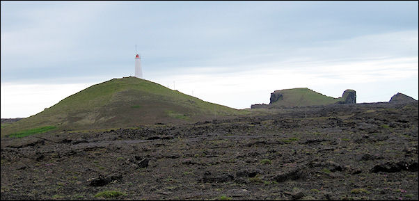
We go farther south to Reykjanesta, the most southwestern point of Reykjanes. We drive to a high place, where we have a wide view of the impressive area, the coast line and geothermic activity. On the top stands a pretty white lighthouse.
Here, at the top of Mt.Valahnukur, the first lighthouse on Iceland was built. It was opened on December 1, 1878, and was the most important lighthouse in the country for a long time. The current lighthouse stands at 73 meters above sea level and was built between 1907 and 1908 on Mt.Baejarfell.
|
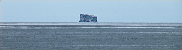
Just off the coast lies the 51 meters high Karl rock, nesting ground of the Arctic tern. We also see Eldey, a high, steep rock with a colony of Northern gannets, 14 kilometers off the coast.
We continue on our tour, passing Grindavik and driving through a bird sanctuary. Besides numerous birds we see golf players and, everywhere along the route, incredibly beautiful mountains in spectacular colors.
|
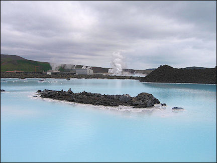
We take the exit to Blue Lagoon, a lake with bright blue water and a natural pool with geothermic seawater, rich in minerals, and wonderfully located between lava fields.
|
We turn back south and drive to Grindavik, where we continue on to Krysuvik, also known for its geothermic area. We see smokeplumes rise from afar.
Because it's getting late, we drive north straight to Hafnarfjordur. But we sto in Seltun to visit one of the most active geothermic areas. Steamholes, hot water springs, mud pots: everything steams and stinks. In many places there are sulphur sediments on the ground.
We drive on, passing beautiful cliffs and pretty, colored mountains, on the bad road to Hafnarfjordur, where we take the #1 back to Reykjavik. Not many tourists visit Reykjanes, except for Blue Lagoon. They don't know what they're missing, it is a wonderful area.
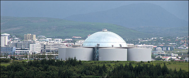
In Reykjavik we drive to Perlan, a panoramic restaurant with a glass dome, built on 6 huge water tanks that can hold 21 million liters of water, originally meant for heating Reykjavik and surroundings. Five of the six tanks are still in use. The Saga museum is housed in the sixth.
On entering the complex our attention is drawn by a huge fountain which spouts water almost five floors up every 5 minutes. It almost makes you think of Strokkur.
In the evening you can have a posh dinner under the dome, while the restaurant turns. It takes two hours to make a full circle. There also is a café with outside seating, open all day, from where you have the same great view as from the expensive restaurant. But you have to walk around yourself. There are binoculars here.
On the way to Iceland the Faerøer were visited