Winter in America is cold I
California, Nevada and Utah
|
Stalked by a trough of low pressure through California, Nevada and Utah: Mojave Desert, Death Valley, the loneliest road in America, the least valuabe land in the USA and the most depressing, unpleasant and boring town in the USA. Off the beaten track in the southwest of America.
Travelogue & photos: Werner Ludwig
|
In the Hilton Airport hotel, near Los Angeles Airport, I check the Weather Channel; for now, a trough of low pressure will influence the weather negatively all over the USA. Great...
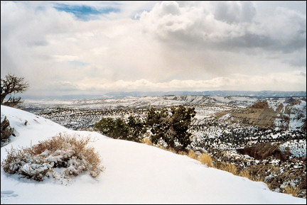
I have left LA and its suburbs behind and now the San Bernardino Mountains rise up ahead of me. It's cold and wet. But in Death Valley, my first destination, at the center of the Mojave Desert, it's almost always nice weather in March.
|
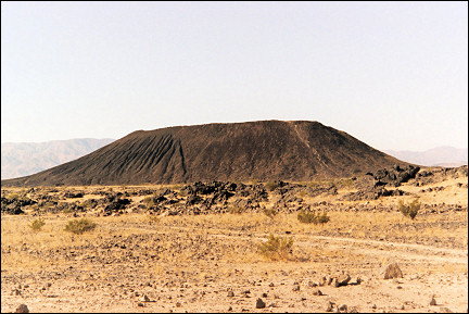
At Barstow I take the Interstate 40 to Newberry Springs, where one can access the famous Route 66. Near Amboy, which looks like a ghost town, is Amboy Crater, a dead volcano crater in the middle of the desert.
Death Valley
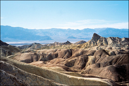
Mountains and hills in all imaginable colors
I don't like the wide and often busy Interstates. I prefer local roads, which are quieter and still good roads.
Kelbaker Road leads via Kelso to Baker, through the Mojave National Preserve, which has vast desert landscapes with bizarrely shaped rock formations and sand dunes (Devil's Playground).
|
Highway 178 is still better; here the Mojave desert is at its most varied: strange geological phenomena and many different desert colors and shades.
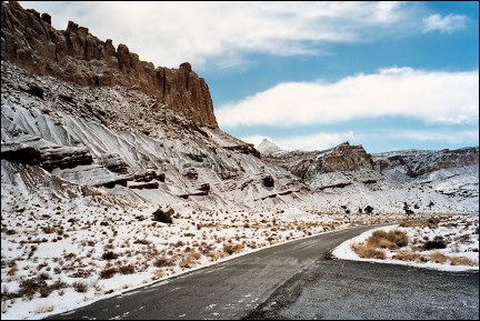
I'm getting closer to Death Valley, which owes its name to the Fortyniners, pioneers who, on their way to the recently discovered goldmines in California in 1849, thought they'd found a shortcut. They got trapped in this valley which is completely surrounded by high mountains. A few men were sent out to get help. It took so long that the stay-behinds had to slaughter draught animals and use their wagons for fuel. When the rescue party finally showed up, people had died already. On foot, the pioneers crossed the Panamint mountains; when they reached the top, one of them sighed: Goodbye, Death Valley!
|
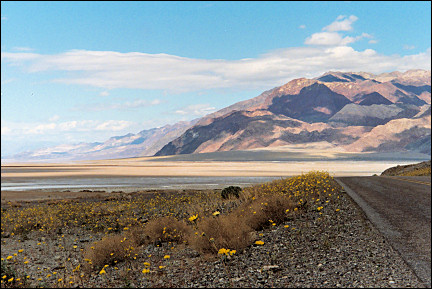
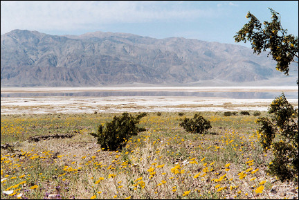
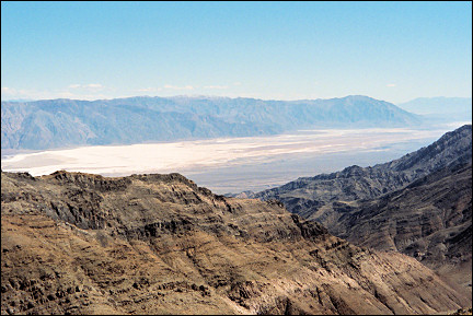
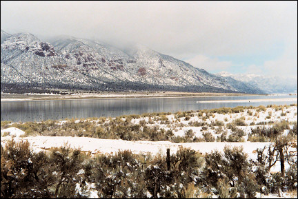
The valley is a sight for sore eyes: the ground is covered with flowers, the mountains display every imaginable color and a big salt lake covers 60 kilometers from south to north.
I drive along Badwater, the lowest point of the western hemisphere, 86 meters beneath sea level; its water is 5 times as salt as sea water.
|
I have a bite at the Furnace Creek Ranch, an oasis in the middle of Death Valley with an open air museum with tools from the era when Death Valley was intensively exploited by miners.
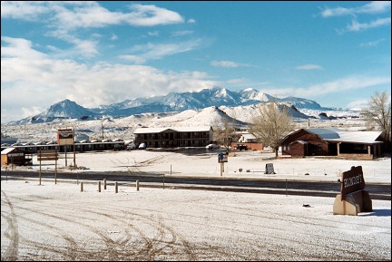
In Beatty, just over the Nevada border, I spend the night in the Exchange Club Motel & Casino where Johnny Quick, former drummer with Bill Haley & his Comets, reigns. The golden record for Rock Around The Clock hangs on the wall (25 million copies sold).
|
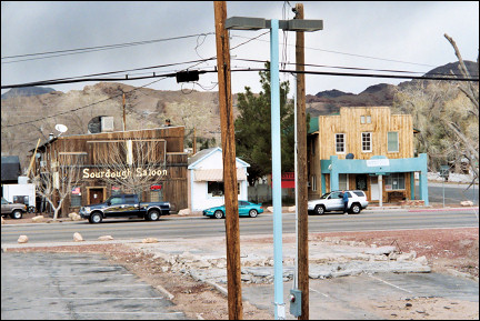
Beatty (1500 inhabitants) has escaped its ghost town destiny. Six kilometers west of Beatty one can visit a real ghost town: Rhyolite, which had 10.000 inhabitants in the heyday of the Gold Rush.
Currently only an excentric Belgian artist lives in Rhyolite and there is a manager who loves to show you the so-called Bottle House. It was built by an Australian gold digger with 70.000 empty bottles.
I turn on Weather Channel again. The weatherman looks sad and promises loads and more loads of snow. But certainly not in Death Valley?
|
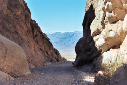
Descending from the Daylight Pass I feel the air get hotter. Down in the central valley I take a right to the north and drive on a bumpy road to Titus Canyon.
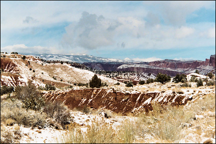
Titus Canyon is a geological rarity: the layers of stone were deposited in horizontal layers in prehistoric times, but forces in the earth's crust pushed and folded them into odd shapes.
I drive back to the central valley and take the road to the hamlet Stovepipe Wells, near an area with large sand dunes. Stovepipe Wells has a gas station, a diminutive motel and a general store. What else? Nothing.
The Charcoal Kilns are shaped like beehives, high up on the slopes of the Panamint Range, the western limit of Death Valley. They were used to make charcoal for the many mines. When I am almost there, I have to stop at almost 3000 meters because of a snowstorm. I turn and take another path, which leads to Harrisburg (a ghost town, named after Shorty Harris) and Aguereberry Point, a high-lying lookout.
|
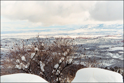
The road is extremely bumpy and I begin to regret I took it. But after 15 kilometers I arrive at Aguereberry Point and am treated to the most wonderful view.
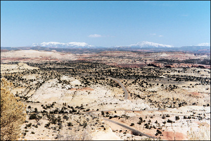
From 2000 meters I can even see Mount Charleston in Nevada. I enjoy the wonderful view until it gets too cold.
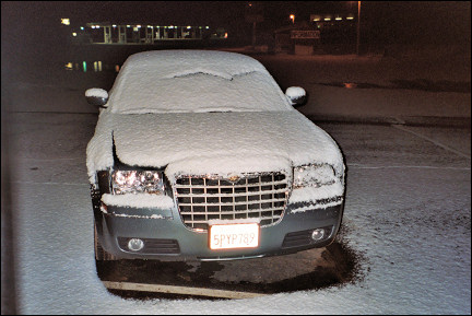
The Chrysler, which I increasingly value because it has no problems with bad and muddy roads, quickly takes me back to the civilized world, where the temperature is a pleasant 25 degrees Centigrade.
Another nice trip is Twenty Mule Team Canyon Road, which is in good condition and about 7 kilometers long. The path goes through the dehydrated badlands in the valley. In the days of borax mining teams of 20 mules carried the ore on this road to places sometimes hundreds of kilometers away. After the introduction of the railroad this was over.
|
Not far from this canyon is another highlight: Zabriskie Point, also known because of the 1969 cult movie named after it. Christian Brevoort Zabriskie was around 1900 the big boss in Death Valley borax mining.
This spot is also in the middle of the bone-dry badlands. One can hike from here to Golden Canyon. Just bring enough water! I follow the hiking trail for a while until a steep decline. An oncoming hiker, overheated and panting, walks the last meters of the trail.
He tells me that he collects Indian earthenware. Lots of fake stuff around? I ask. Excactly, he says. The secret is on the inside, he explains. Fakes feel too smooth on the inside, the real stuff is rougher.
|
I drive back to Beatty while the sun sets behind the Panamint Range. In Beatty, 1100 meters higher than Death Valley, it's freezing cold and there is an icy wind. I wonder what this means and turn on the weather report.
They predict lots of snow, especially in the north and northwest of Nevada. As it happens, I'm going there tomorrow...
Nevada
The loneliest remote corners of America
|
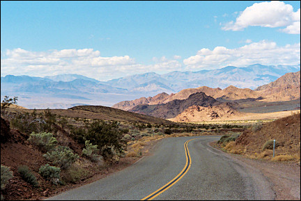
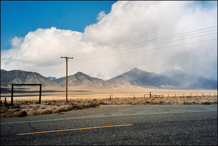
Central Nevada looks virtually uninhabited: villages are 80 kilometers apart and between them are high mountain ranges and scantily overgrown plains.
The first town is Goldfield, once the biggest town in Nevada. After the Gold Rush all that remained was a chaotic village whose inhabitants seem to compete who can stack the most car wrecks on their property.
The next town, Tonopah, looks a lot wealthier. In the past gold and silver were found here. Nowadays it's mostly turquoise.
|
I take Highway 376 in northern direction. Except for a remote farm or mine, there are no signs of any human presence here. And here is the promised bad weather: the white mountain peaks are obscured by grey snow clouds.
It's snowing, but it's not much. Highway 305 North seems even lonelier. Meanwhile the snowstorm gets worse. When I get out of the car to take a picture, it's terribly cold and the wind is icy. Why didn't I stay in Death Valley?
Only 140 kilometers to Battle Mountain, which is named after fights between pioneers and local Indian tribes like the Shoshone. Nowadays the village is nicknamed "America's armpit." Under the heading "Why not the worst" the Washington Post looked for the most depressing, unpleasant and boring town in the USA and Battle Mountian best filled that description.
|
Arriving in this town with 3000 inhabitants I see what they mean. There is really nothing interesting here and a nice motel is nowhere in sight. The snowstorm also became worse, so that adds to the dismal picture. I take a room in the Comfort Inn, the least horrible motel.
Half an hour later I stand at the window, staring at millions of snowflakes. I caught a nasty cold, and a sore throat as well. The neighboring Shell gas station completes the Gothic picture: the "S" of the neon sign doesn't work, so I am looking at the word HELL, in red and yellow lights.
The temperature is far below zero and since yesterday I can't get the tune "Winter in America is cold" out of my head. I leave Battle Mountain. After a while on Interstate 80, I turn south near Carlin. Luckily there's not a lot of snow here.
Highway 278 looks a lot like the road I traveled on yesterday, but there is agrarian industry and I even pass by a small airport. Lots of road kill here, though.
|
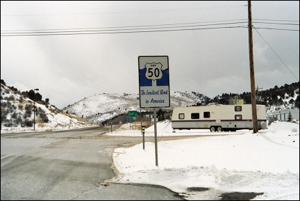
After two hours I reach the junction with Highway 50, known as "the loneliest road in America." Let's see if that's right. Yes, it's true. During the almost 100 kilometers to Eureka I see only two cars. Eureka has a historical town center which has been nicely restored.
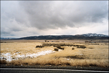
Because I need to drive 600 km today, I keep driving east. Snow falls again in heaps. But that also means that the beautiful landscape of Nevada is covered with snow and that is a remarkable sight.
I drive through Ely, where everywhere people are cleaning their driveways and huge snow ploughs are shoveling snow from the streets. There is a restaurant and I decide to have a bite. After that, I feel much better.
|
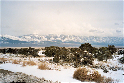
The last stretch to Delta in Utah, another 250 km, leads through the Sevier Desert and soon I pass by Sevier Lake, usually a dry salt lake, but now the salty plain is flooded and it looks like a real lake. One could imagine being on an alien planet here.
Utah
The most worthless piece of land in the USA
After another two hours driving in the desolate Sevier Desert I finally arrive in Delta, a rural town. It is surrounded by vast pastures with black cows.
The receptionist in the Best Western motel in Delta tells me that snow is coming. Tell me something I don't know... I tell her that the trough of low pressure has been following me for already two days. Good, she says, in that case you can take the snow with you when you leave.
Just like in other small towns, there is nothing to do in the evening in Delta. So I go to bed early and dream of nice weather.
|
Today I drive through mountainous areas to the south of Utah. The first 50 km are still farmland, but later the landscape becomes a wild mountainous area with a layer of snow. Am I ever going to get rid of it?
Just outside Scipio I pass by the Scipio Reservoir, a beautiful and currently half-frozen lake.
The farther south I get, the greyer the air becomes. And yes, it's snowing again. A bad snowstorm. I keep driving behind a pick-up truck, using it as a snow shovel, because there's not much visibility. But soon it turns onto a drive-way and I have to deal with the weather on my own.
Without any problems I arrive in Torrey, the operating base for Capitol Reef National Park. This is a remote and therefore rarely visited park. I follow a sign to a scenic view, but it starts to snow here too and there isn't much to be seen anyway. Goosenecks has a nicer view: here the Fremont River has cut out a deep and winding canyon in the land.
I decide to drive to Hanksville via Highway 24, one of the most spectacular roads in Utah. It crosses an area that actually is more like a geological circus: every 5 minutes the landscape changes because a different type of stone or rock appears on the surface.
|
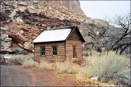
Ik pass by the Fruita School, built in 1880 for Mormon pioneers' children. It held 12 students. The interior looks exactly like it did then. The tough Mormon pioneers planted orchards which are still here, but they themselves left because of the frequent flooding of the Fremont River.
Hanksville has about 80 inhabitants. I take a room in the Whispering Sands Motel, where the cold wind blows through the cracks in the wooden building. Luckily I find a heater and some blankets.
In the evening I hear the wind increase to stormy and then there's a snowstorm. Shivering I smoke a last cigarette outside while the lights in Hanksville go out one by one.
|
Winter in America is cold
And I just keep growing older...
I'll be...
It looks sunny and the wind has stopped. I clean my frozen windshield for the umptieth time, check out and take Highway 24 in the opposite direction. The snow makes the landscape look even more bizarre than usual.
|
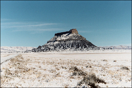
Off the road Factory Butte is visible, a strange looking mountain which for that reason serves as a point of orientation. The land around it has been officialy named "the most worthless piece of land in the USA." There is a path, so I take it.
This time I am not the only visitor. There is a decrepit Mercedes with a guy with a wild black beard in it. He is originally from New Jersey and moved here to escape the East Coast rat race.
The road over Boulder Mountain is still open, he says, but for how long... He points at the sky. Big white clouds gather over the Henry Mountains. It looks quite inocuous, but experience has taught me that the weather here can change completely within an hour. It's time for me to leave... fast.
|
I drive farther west and stop at the Visitor Center of Capitol Reef National Park. A ranger takes me to a scale model of the area and gives me some brochures in which she marks recommanded hiking trails.
She warns me: if I want to go somewhere or see something today, I have to hurry, because it is going to snow.
The scenic route is an 18 km road through Capitol Reef. Erosion is written with a capital E here: it is responsible for the development of the domes, arches and cliffs around here.
|
By Capitol Gorge the paved road ends. One can continue on an unpaved road which leads deeper and deeper into this area, but it's covered with snow now.
I drive back on the scenic road and forget to ask if the park rangers know anything about the condition of the roads. I drive to Torrey, where I take a turn to the next sight of south Utah: Scenic Byway 12, paved only in 1985, with all kinds of sights along it. This part is also called "land of a thousand lakes," and is an eldorado for fishermen.
I am in luck, the gate to Highway 12 is open, so crossing Boulder Mountain, a 3500 meters high giant, should be possible. If the road had been closed off, I would have had to make a detour of at least 200 km. Slowly I ascend to almost 3000 meters and meanwhile the weather gets worse. Lots of snow, which means beautiful winter views.
|
When I descend, the problems begin; it is snowing hard and the road is covered with snow. Because the road gets increasingly steep, the car keeps slipping. It takes a lot of effort to keep it on the road.
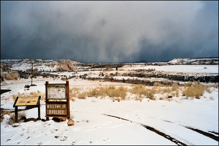
Half-way on the mountain is Boulder with the Anasazi State Park Museum. The Anasazi were Native Americans who lived here around 1100. Around 1300 they suddenly disappeared. Historians assume that was because of a famine, war or droughts. Here an Anasazi village has been excavated partly. It had 200 inhabitants.
|
When I have almost reached the foot of the mountain, I see an animal coming my way, a pick-up truck 20 meters behind it. The animal strolls leisurely instead of scurrying off into the bushes. When I get nearer, it turns out to be a skunk. Oh, no...
If your car gets sprayed by one of those animals, you have to put it away for at least a month, because the smell is so bad that you can't drive it for a while. I give the animal a wide berth the animal and it looks at me with beady eyes. The driver of the pick-up truck laughs when he sees my worried face, but I have passed by the animal without problems and he still hasn't.
When I'm finally down the mountain I stop to stretch my legs. The sky looks threatening and after a few seconds I realize it's the bad weather I just left. It is really following me.
|
The next part of the trip goes over the Hogback, and the road is not much more than a narrow dam between to chasms. It's not for people with fear of heights, but the view is wonderful.
A little farther west it gets even prettier: a vast slick rock landscape, east of Escalante. Head of the Rocks (or Escalante Canyons) is a popular hiking area in this far corner of Utah. Every few kilometers there are parking lots which offer stunning views.
Escalante is small, but has a modern gas station with a well-stocked store. I stop for a cup of coffee and ponder my options. Now that my day in Capitol Reef is not going to happen, I all of a sudden have a day extra to spend. Because Bryce Canyon is on my route anyway, I decide to spend a day there and break up the long drive I had planned for today.
|
Half an hour after leaving Escalante all hell breaks lose. It's snowing so hard that I litterally can't see a thing. This is what they call a white-out here. I can't see the car 30 meters ahead of me anymore. I can't stop, because the next car would slam into mine. I can't pull over, because how would I ever be able to get back on the road again?
I vaguely see the poles along the road and try to keep these as much as possible at equal distance from my car. The only thing I can think of is to honk every few seconds, like a ship in a fog, and hope someone hears me. After ten minutes, but it feels like an hour, the visibility gets a little better. It turns out I passed by the exit to Bryce Canyon a while ago. Because Bryce is unreachable because of the snow anyway, I am doomed to keep driving.
|
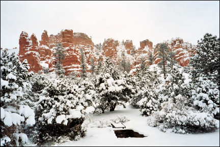
Without accidents I reach the end of Scenic Byway 12, at a spot called Red Canyon; I park the car and with a sigh of relief I notice that I haven't experienced anything like this in my whole life. And also that I seem to have arrived in some kind of X-mas card.
Convinced that I have the worst behind me now, I take the 89 South to Kanab. It's dry and the road is clean. And then it happens: four cars in the other lane, 3 trucks and a pick-up truck. I steer the car into a long curve to the right and at the same time the first truck hits a puddle of slush, which completely covers my windshield. I can't see a thing! Because I am in a curve to the right, I have to keep the steering wheel in the same position, or I'll slam into an oncoming car. While I prepare for the worst, the windshield wipers glide back and I see the road again. Miraculously, I am still in my lane and can even take the next bend without any problems.
This is a day with obstacles and it's not over yet. I smoke a cigaret to recover from the scare I just got. I drive to Kanab, which looks picturesque for American standards. It is often used for film shoots.