Winter in America is cold II
Arizona, New Mexico and California
|
Stalked by a trough of low air pressure through Arizona, New Mexico and California: visiting Navajo, Hopi and Apache reservations, the White Mountains, City of the Rocks, Wyatt Earp's and Doc Holiday's Tombstone, lots of deserts and the San Bernadino mountains. Off the beaten track in the southwest of the USA..
Travelogue & photos: Werner Ludwig
Fredonia is the first village I pass through after leaving Utah and entering Arizona. I'm on Highway 89, the access road to the north side of the Grand Canyon. But part of the canyon won't be open to the public until May, because of the snow. I have no doubt that that is true, since it is still snowing.
I have to travel another 80 km today. Under these circumstances that could take a while, because again I have to cross a high mountain. Ahead of me is a car which doesn't go faster than 20 k/p/h. I noticed that Americans are often clumsy oafs when driving: they either can't of are afraid to drive. We Dutch laugh when we see signs that tell you to drive 25 m/p/h (approximately 38 k/p/h) in a bend which we would take at 70 k/p/h without blinking an eye.
|
After a dangerous drive over the snow-covered mountain I am finally on a plain and the snow has stopped. In the distance I see the Vermillion Cliffs. On one of them is the Cliff Dwellers Lodge, very popular with fly-fishers and boat owners, because the Colorado River is nearby.
It's almost midnight when I think about today. I could as easily have ended up playing the harp on a cloud with Elvis, Miles Davis and Frank Zappa. While the storm rages around the motel, I switch off the light. Tomorrow's another day. Let's hope less eventful...
I open the door and everything is white. Oh no! Not again. My neighbor, Jack from Phoenix, laughs at my disappointed face. He goes boating for a couple of days on the Colorado river in his speedboat. He asks what my plans are and with every town I mention, Jack tells me that they just had a record amount of snow. Great...
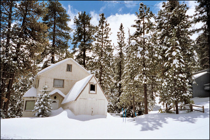
At the foot of the Vermillion Cliffs I find the most bizarre kinds of rocks. They look like huge tennisballs on pedestalls with wigs of powdered sugar because of the snow. Someone succeeded in turning one of those weird rocks into a house. The overhanging part is of course the roof and on the sides walls have been build of slabs of sandstone.
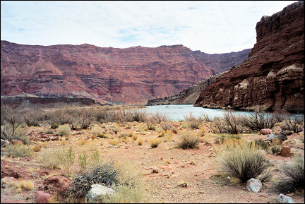
After having checked out I drive to Lee's Ferry, a spot on the Colorado river where boats are launched. There is no snow, for a change. Around 1875 a John Lee hid here, because of problems with the law and started a ferry service. Besides boating and fishing, hiking is great here. Nearby are the Paria Canyon and the Paria Wilderness.
|
Because the first snowflakes begin to fall again, I travel farther south through the Painted Desert, usually spectacularly colored, but now mainly white.
I take a right exit to the east, into the Navajo reservation. After another turn, to the south, I am in the Hopi reservation, which is completely surrounded by the Navajo reservation. The Navajo have adapted to white culture and are doing relatively well. But the Hopi lead an isolated life and are not very interested in the outside world. The Hopi are known for their artful Kachina dolls and their Snake Dance, a ritual dance with live rattlesnakes.
The two tribes quarrel over mine concessions: a lot of coal is found here and there is a dispute about the exact border between the two tribal areas.
|
In the hamlet Dilkon I set course for Holbrook. The main street of this place is actually part of Route 66. From here it's not far to the Petrified Forest.
Between Holbrook and the Petrified Forest everything is covered with half a meter of snow, so I won't be able to see much. With a deep sigh I continue my drive to St. Johns.
|
From St. Johns I drive into the White Mountains who do honor to their name: here also everything is covered with a thick layer of snow. I spend the night in Springerville. It's getting monotonous, but also here it's freezing cold. No wonder: we're at a height of 2000 meters. The legendary John Wayne owned a ranch here.
I leave Springerville in southern direction. The road through the White Mountains is also called the Coronado Trail, after Francisco Vazquez de Coronado who left Mexico in 1540, going north to find the legendary Seven Golden Cities of Cibola, where the streets were paved with gold. He didn't find them. Which makes sense, because they don't exist. What he did find was the Grand Canyon and lots of problems with the Pueblo Indians in New Mexico.
|
First I drive through rolling hills in the White Mountains, the road is excellent and winds through the largest collection of ponderosa firs in the USA.
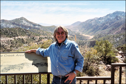
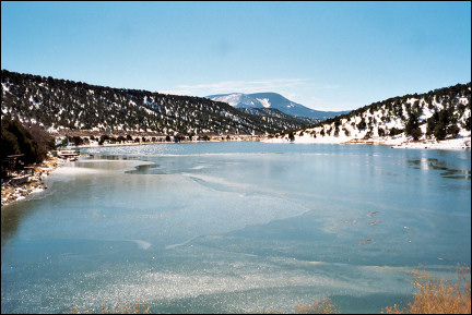
I reach a beautiful half-frozen lake, the Nelson Reservoir. Here the road gets steeper and has more bends. Luckily there's no snow on the road, but I have more than enough to do dealing with the sometimes dangerous descents. A sympathetic ranger takes a picture of me at a panoramic view point.
|
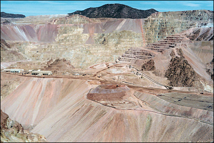
He tells me that 15 minutes ahead of us is the largest copper mine in the USA. He didn't exaggerate: the hole in the ground near the town of Clifton is enormous.
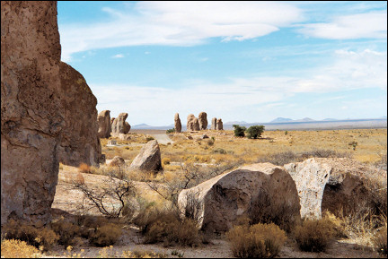
New Mexico
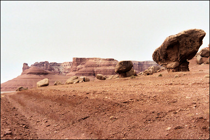
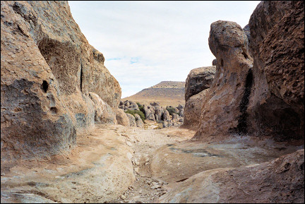
A collection of rocks in an empty landscape
When I finally leave the mountains and arrive in Clifton, I notice that the weather is nice. I can take off my shirt and that hasn't happened since I left Death Valley.
I take Highway 78 East and cross the border to New Mexico. The bizarre, rough and wild landscape of Arizona is replaced with rolling hills with trees and here and there a farm.
|
Silver City is an average-sized town, which owes its name to the discovery of a large amount of silver here around 1870. William H. Bonney, a.k.a. Billy the Kid, grew up and took the first steps of his criminal career here.
I leave Silver City in southeastern direction and the landscape changes again: an empty desert with a lone mountain here and there. After a while I take a left turn onto a narrow road which leads to the City of Rocks, a collection of big rocks in the middle of the barren and empty landscape. They are eroded monoliths of volcanic ashes.
|
There are star parties here; New Mexico has the darkest sky of North America, so it is the best place to watch the stars at night.
I drive farther south and turn west onto Interstate 10 at Deming. The only distraction is the long cargo trains riding parallel to the highway. I'm glad when I can exit to Highway 80 which takes me to the farthest south of the USA. At least there the weather should be nice.
The remote desert looks desolate. A memorial along the highway memorizes the surrender of Apache Chief Geronimo to the American army. For years Geronimo succeeded in evading the authorities by crossing the border to Mexico. Until Geronimo realized that it had to stop because the Apache were starving to death.
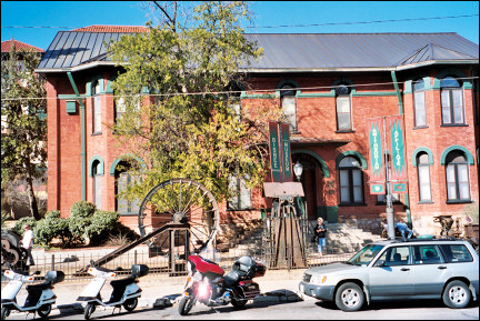
Douglas seems completely void of anything interesting. Bisbee, a former boom town, looks better.
|
Bisbee doesn't look like the average American town, it could be somewhere in Italy, France or somewhere else in Europe with its steep, narrow streets and houses build on the hill sides. Bisbee has a historical museum which seems nice. There is also a Bisbee museum.
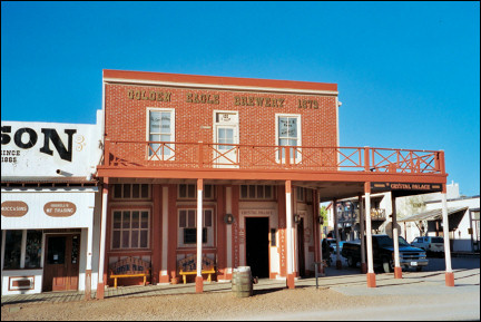
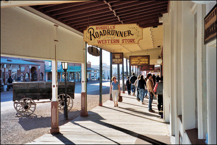
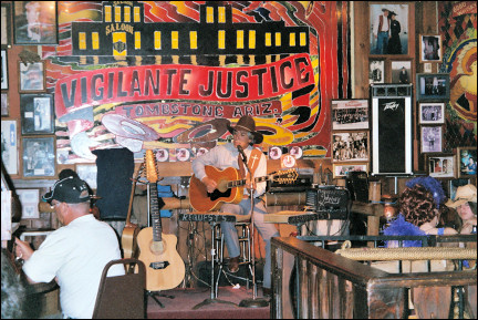
Tombstone
The Wild West is revived for tourists
Half an hour later I reach Tombstone, the ultimate Wild West town. Ed Schieffelin announced in 1877 he would find gold here. He was told: "All you're gonna find out there is your tombstone." Ed still left for this wild area. Legend has it that his mule escaped time and again. Once, when Ed was chasing it, he got so mad that he threw a stone at the animal. He missed, but on the spot where the stone landed, he saw something shiny. Exactly: silver. Ed became instantly rich and called the town Tombstone, to spite everyone who had discouraged him from going there.
|
Tombstone at first was a lawless golddiggers camp, because there was no state of Arizona. It still was Pioneer Territory. No wonder that more and more people demanded a law enforcement agency.
Which came, in the form of Wyatt Earp and his brothers Morgan and Virgil and also his friend Doc Holiday, who actually was a dentist, but also a gambler and gunslinger.
Little by little the group got some grip on the chaos; Tombstone had become the victim of "Vigilante Justice," which means that you could end up on the gallows for just being a pain in the neck or being suspected of cheating with poker.
The Earp brothers and Doc had problems with a group of cattle thieves. Emotions got so stirred up that it ended in one of the best known shootouts in the Wild West, the shootout at the OK corral.
|
To conserve this piece of American history, the main street - Allen Street - was restored to its former glory. The Bird Cage Theatre, the OK corral, Big Nose Kate's Saloon, they can all be admired.
Of course this was done to attract tourists: every day actors, dressed up like Wyatt Earp and Doc Holiday, perform a "Shootout at OK Corral Show" and the streets are populated by extras, dressed as cowboys. There are also horse carriages with cowboys on the coach box, who tell the tourists the history of Tombstone while driving them around town.
|
Everything in Big Nose Kate's saloon has to do with Wyatt Earp and Doc Holiday, the Wild West theme is used to the limit. There is a singer who performs Country & Western music and in between songs tells anecdotes about the old Wild West.
In the Longhorn restaurant I read in old newspaper articles that this used to be the Bucket of Blood Saloon, where Virgil Earp was shot in the shoulder from the second floor.
The Grim Reaper was a regular guest in Tombstone and all those victims and outlaws had to be buried somewhere. For a long time Boothill Graveyard was neglected, but in the 1960s there was intensive research and the cemetary was restored.
The first thing I notice is that many graves have the inscription "Unknown." They apparently weren't very thorough in those days. But they did have a great sense of black humor, judging by the inscriptions on some headstones. Like this one:

|
Here lies Lester Moore
Four slugs from a forty four
No Les
No more
Or this one:
Here lies George Johnson
Hanged by mistake
1882
He was right
We was wrong
But we strung him up
And now he's gone
The victims of the shootout at the OK Corral are also buried here. Billy Clanton and Tom and Frank McLaury lie brotherly next to each other. I find a tombstone with the name Dutch Annie. She was the madam of one of the many brothels in Tombstone. This makes clear who were the most successful entrepreneurs in Tombstone: undertakers and brothel owners.
Apache land
Do you have illegal Mexicans in your trunk?
I leave Tombstone in northern direction and fairly soon get stopped by the Border Patrol, who would like to know if I have illegal Mexicans in my trunk. Illegal Mexicans? No Sir. Okay, you can go.
Near Benson I take Interstate 10 East. On a parking lot is a memorial plaque which commemorates Cochise's story, another famous Apache chief. Initially Cochise had no problems with the arrival of the white pioneers. But after he was accused of kidnapping a white girl, he traveled to the nearest fort to prove his innocence with his men and they were immediately locked up. Cochise escaped, but his men were hanged. After this Cochise fought a guerilla war for years. He was never caught and died of old age.
At Willcox I take Highway 191 North. A few years ago it was called Highway 666, but there were so many accidents that people began to blame the number 666, which in the New Testament book of Revelations is know as "the number of the beast." Superstitious nonsense of course, but try to tell that to the fundamentalist Christians here.
|
In the San Carlos Apache Reservation, the biggest in the USA after the Navajo reservation, I notice that the living conditions of the Apache have structurally improved.
Shabby wooden sheds have made place for neat new buildings and also the Rez Cars, antique wrecks which were kept going in every way possible, are replaced with newer vehicles.
The Apache also seem friendlier than ten years ago, when they would snap at you or totally ignore you.
Around 1900 Globe was a boom town because of the discovery of a large amount of silver. The silver was exhausted soon, but the town survived because enormous amounts of copper were found. Globe is surrounded by a beautiful area where one can camp out, hike, ride mountain bikes and boat or fish on the nearby Lake Roosevelt and Lake Apache. It's nice to drive along the Apache Trail, a meandering unpaved road along the shores of Lake Apache. President "Teddy" Roosevelt thought this was the most beautiful area he'd ever seen and promoted its conservation.
From Globe I take Highway 60 North, according to the map a scenic road. It meanders through the western part of the White Mountains and offers one panoramic view after another.
|
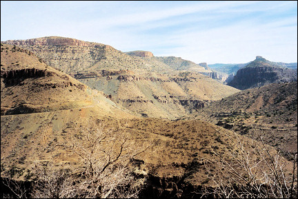
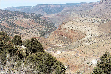
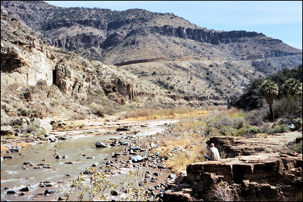
A sign tells me that I am back in the San Carlos Apache Reservation and the surroundings become increasingly beautiful. After a descent I end up near the Salt River Canyon, a nice surprise in terms of natural beauty.
At the bottom of the canyon, near a bridge over the Salt River, is a parking lot where Apaches sell Indian jewelry. The Apache turn out to be accomplished silversmiths, just like the Navajo and the Hopi. Their specialty is the combination of silver and turquoise. One increasingly sees knock-offs from Taiwan, which means you have to look carefully to find the real thing.
|
As soon as I leave the Apache reservation, I arrive in Show Low. Around 1870 two men found the settlement too small for the two of them. Instead of shooting each other, they decided to play a game of cards to decide who had to leave. One of them said: "If you can show low, you win."
The other one turned up a three of clubs and said: "Show low it is." The winner stayed and the loser lived the rest of his life in nearby Pinetop.
I take a turn to the west and drive through a scorched landscape. Forest fires have destroyed thousands of hectares of woods here.
Payson is situated beautifully between pine forests. I stop for a cup of coffee and decide to spend the night in Flagstaff. The route to Flagstaff leads through thick forests with Ponderosa firs. Not far from Flagstaff I pass by two frozen lakes, Mormon Lake and Lake Mary.
Next morning the sky is dark-grey and snowflakes fall. I take Interstate 40 West and near Seligman I exit to Route 66 to Kingman. It is a long, straight and empty road.
|
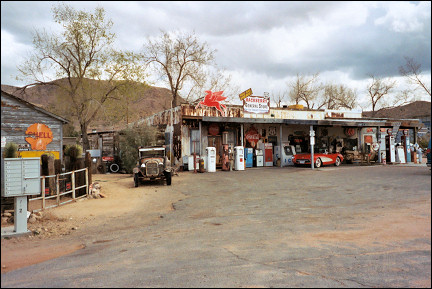
In the hamlet Hackberry I park my car near one of those typical trading posts, of which there used to be many along this road. Now that Route 66 has become popular again, some are restored.
Descending from Kingman to the Mojave desert, the temperature becomes more pleasant. The exit to the south leads through a curious town: Lake Havasu City on the shore of the lake of the same name. Established only in 1963 it is mainly popular with anglers, boat-owners and retired folks with lots of money.
The "London Bridge" over the Colorado River used to span the Thames in England, but it sank. Multi-millionair and founder of Lake Havasu City Robert P. McCulloch bought the bridge for $2.5 million. It cost him another $7 million to take the bridge apart stone by stone, ship it and rebuild it here.
I decide to keep driving towards Blythe, California. According to the brochures, it has 350 days of sun per year.
California
Here is where Hollywood finds all those horror actors
I cross the bridge over the Colorado and I'm back in California. After 20 km I arrive at the Agricultural Inspection Station, where I'm asked if I have fruit with me. No, I ate it all. Okay, have a safe trip.
I turn left southward; the Colorado now is left of me. A thick layer of clouds is moving towards me from the north. Is it something I said?
Blythe is known territory. We have spent the night often in this village with its many excentrics. One is almost tempted to ascribe this to 150 years of inbreeding. If you wonder where Hollywood finds its horror actors: here, in Blythe.
I check in in the Sahara Inn, a pleasant motel with swimming pool where I enjoy the sun for an hour or so. Then I notice that the trough of low pressure has followed me here as well.
This must be one of the 16 days per year that the sun doesn't shine in Blythe. I decide to take drastic measures and to move to Yuma. Farther south is impossible and a hotter area doesn't exist in the USA.
Arizona
Mean pin-cushions shoot needles
Interstate 10 takes me in 10 minutes back to Arizona. I take the exit to Quartzsite. Normally around 1500 people live here, but during the winter the town is flooded with snowbirds, retired people who have exchanged their house for a supersized mobile home. In large numbers they come here to spend the winter in this pleasant climate.
Highway 95 South takes me directly into the Sonora desert where saguaros grow, a well-known giant cactus which can reach a height of 15 meters. There are also many chollas, a kind of cactus that looks innocuous from a distance. But its looks are deceptive: locals call it "the meanest motherfuckers of 'em all."
When you touch it, the cholla shoots its needles deep into your flesh. By accident I step on a cholla and it takes me 15 minutes to remove the needles from my shoe sole: they were propelled a centimeter deep into it.
|
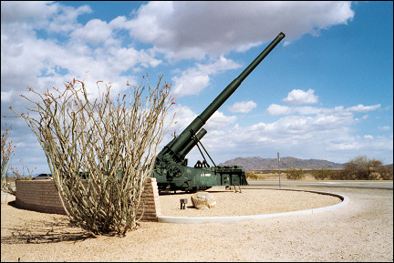
A little farther south I pass by Yuma Proving Ground, where everything that explodes is tested by the army. There's enough space here.
Yuma is the third fastest growing city in the USA. It's incredibly crowded, complete with traffic jams. The weather is great, but soon the bustle turns me off. Yuma is not for me. I should look for a quieter place. But where?
Brawley seems the only option, over 100 kilometers west. The route leads through an enormous sand plain, the Glamis Sand Dunes. The area is about 70 km long and 15 km wide and is popular with Dune Buggy Riders. Many films were shot here, among others Star Wars.
Brawley is a town with two faces: the eastern part is ugly and has large dairy farms, where thousands of cows live boring and monotonous lives, and the western part, where the town center is, which is nice.
It seems it was a good thing to go south: this morning there is a friendly sun and the temperature is pleasant.
From Brawley I drive north. The first hour through an agricultural area, but then along the shore of the Salton Sea, an 80 km long lake which was created by the flooding of the Colorado River. As a recreational area it's a failure: the houses along the shore are mostly deserted and it smells like dead fish.
Because I don't feel like going to crowded places like Indio and Palm Springs, I decide to turn east at Mecca. Lemons, oranges and grapefruits as far as the eye can see. And then suddenly, I'm back in bone-dry desert.
I drive over the viaduct of Interstate 10 and immediately am on the access road to Joshua Tree National Monument. When I arrive at the Visitor Center and get out of the car, there is a strong, chilly wind.
|
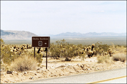
First I pass by the Pinto Basin, a vast, arid plain where Indians lived in the past. They left because of draughts. A little farther is the Cholla Garden. Here there are hundreds of those mean pin-cushions together.
It's remarkable that many Americans don't seem to know anything about the agressive nature of the chollas. I have to warn several people not to touch them.
The first 35 kilometers there is no Joshua Tree in sight, but then hundreds appear. They are a kind of yucca, with long, hard and knife-sharp leaves. Woe to anyone who bumps into them, their nickname is Spanish Dagger for a reason.
For photographers, hikers and mountainbikers this is an Eldorado with trails to mysterious destinations like abandoned mines. The park is also a geological circus, judging from the strange heaps of stones and the so-called Jumbo Rocks.
I leave the park at Twentynine Palms. The road, which is called the Utah Trail, leads through a practically deserted part of the Mojave Desert. This is the territory of the Desert Rats, mostly poor retired people who live in wooden houses on the edge of the desert. No running water, no electricity, because that's too expensive. How do they wash themselves? I guess they don't...
Crossing a mountain top I see Bristol Lake in the distance, a salt lake that is used by the Chloride Company, the only company in the hamlet Amboy. I walk on the salt lake for a little while. The salt crust creaks like a not completely frozen ice rink. In the distance is the black cone of the Amboy Crater where I stood two weeks ago. I have closed the circle, many experiences richer.
I leave the badly paved Route 66 behind me and take the Interstate to Barstow where I want to spend the night. To my surprise it's freezing cold in Barstow. Tomorrow back to Los Angeles. Maybe the weather will be nice there. Probably not.
Barstow is 280 kilometers from L.A. and via the Interstate a little over three hours driving. I don't feel like doing that: both Interstate 15 and 10 are extremely busy.
|
So I take a route through the San Bernardino mountains, which will leave me only 100 kilometers on the Interstate. I leave Barstow and take Highway 247 South. Instantly I'm back in the Mojave desert. Instead of 30.000 cars, I meet three.
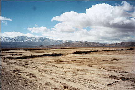
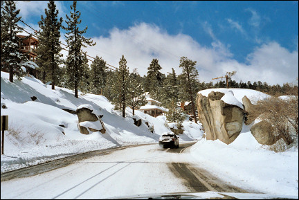
In the distance the San Bernardino mountains are visible, complete with white snow wigs. The oncoming cars worry me: they all have at least 20 centimeters snow on their roofs.
In Big Bear City traffic plows through a thick layer of snow and I realize it's a ski resort. On the edge of town is the beautiful Big Bear Lake, but I hardly look at it, because a dark grey sky is approaching.
|
Something else also worries me: I passed already three signs with the words "snowchains required." I take a deep breath and begin the descent from Big Bear City. This is not going to be a fun ride, another snowstorm has just started.
Ten minutes later a patrol car of the Highway Patrol is behind me. I pull over and wait. A sturdy policeman with his hand on his gun approaches.
Hello Sir, where are your snowchains?
I haven't got any...
What are you doing out here then?
Trying to get out of this mess.
Okay, drivers licence and car papers, please...
I obey and give him my papers, which he scans thoroughly. He returns them and snaps at me: "You'll go back to Big Bear City, buy snowchains and put them on, understood?" I can't argue with that. I want to say something about cars without chains that pass us, but I swallow that remark just in time. Shut up, shmuck! Be glad they don't give you a ticket...
I want to wait until the patrol car leaves, but the policeman is on to me. He waits until I turn before he gets in his car.
Great! All my plans messed up. But if someone thinks I am going to buy snowchains on the last day of my vacation, they're crazy.
The only thing I can do is take the same way back. An hour later I'm back in Lucerne Valley. I take Highway 14 and little by little it gets busier. Then a short stretch on Interstate 5 and the San Diego Freeway and I am back in Los Angeles after 7000 kilometers driving. One and a half hours of sitting in traffic later, I see the exit to the airport, where my hotel also is.
Next day the weater is great. I read in a newspaper that the rest of America still suffers from the trough of low pressure, but that it finally is going to give way to better weather.
The Jumbo turns east. Beneath me, I see the desert where I toured the last couple of weeks. In hindsight, it's good that I was alone, my girlfriend would have been scared riding in all those snowstorms. But because I unintentionally drove so many kilometers, I saw a lot.